About Port du Lavandou
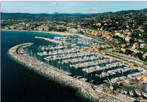
Le Lavandou is protected by a jetty and a mole, and has depths of 1 to 4m.The original basin is used by small craft. Anchoring is prohibited within this basin on account of mooring chains lying on the bottom. Quays at the W ends of the mole and the breakwater are reserved for the use of local ferries. An extensive yacht basin, protected by a curved breakwater, lies close SE of the original basin. Anchorage may be obtained, in depths of 15 to 20m, muddy sand, good holding ground, about 0.2 mile SE of the harbor. 1050 berths in 3 basins (<30m) of which 100 visit.
Einrichtungen
 Strom
Strom BenzinDiesel
 Wasser
 WLAN
WLAN Duschen
 Toiletten
 Essen
Essen Bar
Bar Bootsbauer
 Wäscherei
 Auskranen
COORDINATES
43.13658 N, 6.37303 E
Port Information
Telefon
Berth Sizes
< 10m, 10-20m, 20m+
Tiefe bei MLW
2 - 3m
Manövrierbarkeit
Fair
Channel Marking
Fair
UKW-Kanal
9
Overseas Visitor Berths
Yes
Katamaran-Liegeplätze
Yes
Stegart
Floating
Style Side To
Yes
Tidal Flow
Negligible
Active Winter
Yes
Weather Forecast
Wed
5AM - 9AM
29 July 2026
 Light and variable.
 Increasing from 22 to 26°C
 Calm sea
 UV Index: 0 - Low
 Sunny
Sunny
Wed
9AM - 1PM
29 July 2026
- S 2 knots increasing to 7 knots.
- Increasing from 27 to 30°C
- Calm sea
- UV Index: 8 - Very High
- Sunny
Wed
1PM - 5PM
29 July 2026
- S 6–10 knots.
- 28°C
- Calm sea
- UV Index: 8 - Very High
- Sunny