About Port Greg Maritime Facility
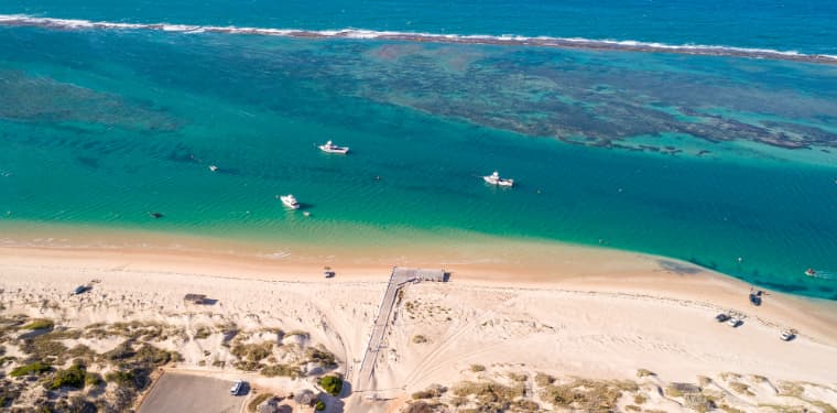
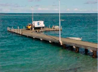
Port Gregory is located 47 kilometres northwest of Northampton and 520 kilometres north of Perth, in the Mid West region. The town has a population of approximately 80 people. It supports a small commercial fishing fleet and also has a small tourist industry. Fishing and diving are popular activities. Port Gregory is situated in open water but protected by 5 kilometres of exposed coral reef, which provides relatively safe anchorage for both recreational and commercial vessels. The reef is long and almost continuous, and about 1 metre high. The Port Gregory Maritime Facility consists of one wooden service jetty and toilets/showers. Important notice There has been significant siltation in the vicinity of Port Gregory Maritime Facility that has substantially reduced the navigable water depths which has resulted in restricted access and/or is inaccessible to vessels. A Temporary Notice to Mariners regarding the reduced depth has been in effect since 16 July 2012. The Department of Transport (DoT) is monitoring the shoreline progression, which has occurred over a number of years as a result of natural coastal processes. Boating facility fees Fees are payable for the use of maritime facilities throughout the State. Please refer to the schedule of maritime facilities fees and charges. http://www.transport.wa.gov.au/imarine/marine-fees-andpayments.asp All customers should contact Department of Transport’s (DoT) Geraldton office, on email MidWest@transport.wa.gov.au or phone 9216 8170 prior to arrival to ensure suitable facilities are available and to receive all relevant documentation and facilitate payment. It is a condition of use that all users comply with DoT’s gas, electrical, insurance requirements and terms and conditions. These documents can be found at https://www.transport.wa.gov.au/imarine/use-ofboating-facilities.asp Waterway Entrance Channel Latitude: -28.187 S Longitude: 114.237 E
Comodidades
Port Information
Telefone
Berth Sizes
Profundidade na MLW
Manobrabilidade
Channel Marking
Canal VHF
Porto de entrada
Overseas Visitor Berths
Vagas para catamarã
Tipo de doca
Style Side To
Tidal Flow
Active Winter
Weather Forecast
 SW 8 knots.
 17 to 19°C
 SW 2.3m at 10s period
 UV Index: 0 - Low
 Mostly fine
- W 7–10 knots.
- 19°C
- SW 2.1m at 10s period
- UV Index: 1 - Low
- Mostly fine
- W 8 knots increasing to 11 knots.
- 19°C
- SW 2.0m at 10s period
- UV Index: 2 - Low
- Mostly fine